
|
Photo Name
DeathValleyRideMap-1-11.jpg
About the Photo
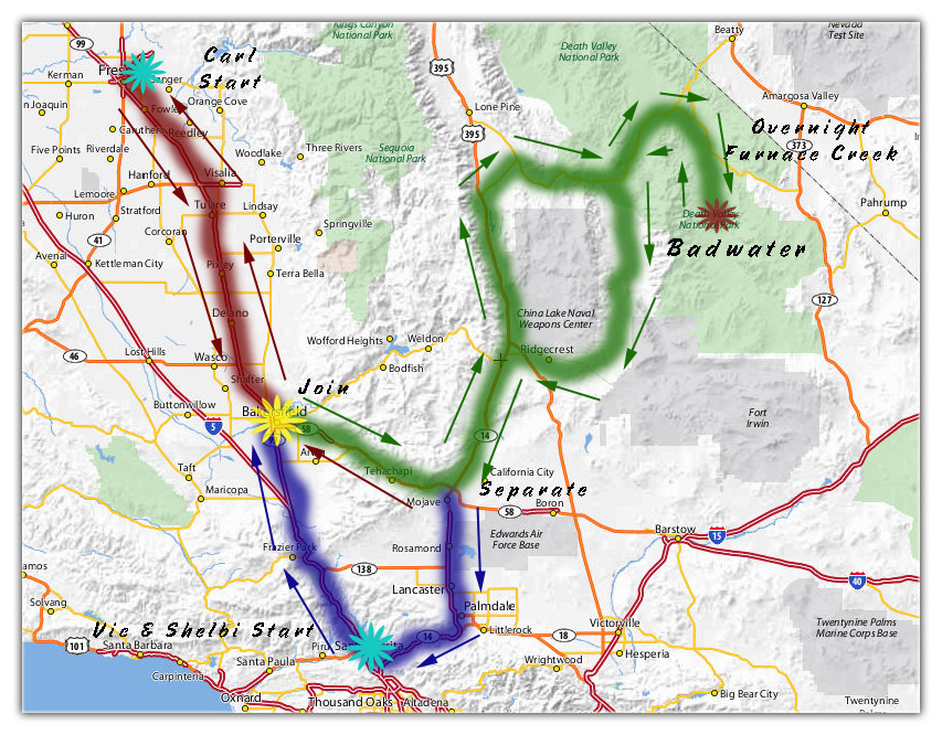
This is common. Vic is a Hollywood Musician and of course, lives near the studios. I live 250 miles north of him in Clovis so we usually meet mid point in Bakersfield at the Denny's, 99 and the 178. This turned out to be the coldest part of the ride for me. I wear a ski suit and a heated vest making it quite comfortable once everything is packed up.Back on the road, we drove through Tehachapi to Olancha where we picked up the CA 190. This took us through the Owens Valley, over some very scenic mountain roads, through Panamint Springs and the north section of the Panamint Valley to the entrance of the Death Valley National Park. Once into the park, we stopped multiple times for photos, and sometimes I stopped alone and caught up later. We stopped at the gas station in Furnace Creek and paid over a dollar more per gallon than at home! Such is life. We also decided to stay over night and find the Badwater Basin the next day. Next morning we had a great breakfast at the Furnace Creek Ranch, and headed out. Badwater Rd was only about a mile away, then about 25 more to Badwater Basin, the lowest point in North America at -282 feet below sea level. We walked from the parking lot to the edge of the water on the (otherwise) dry lake bed. Awesome! The scenery was beautiful, the air was clean, and it was only 71 degrees! We had to backtrack through Furnace Creek to get home, or be willing to drive to Baker at the I 15. Gas at Panamint Springs, then we went south through the Panamint Valley to Trona. We took that route because I wanted to see Trona. So what do they do in Trona? They mine trona. So, what the hell is trona? Trona (trisodium hydrogendicarbonate dihydrate); Na3H(CO3)2 2H2O is an evaporite mineral. It is mined as the primary source of sodium carbonate (also known as washing soda or soda ash) in the United States, where it has replaced the Solvay process used in most of the rest of the world for sodium carbonate production. Westbound through Inyokern, we then took the US 395 north to the CA 14 and made a U turn to head towards Mohave. We split ways at the CA 58 where I headed over Tehachapi again, then the CA 99 to Clovis. Vic and Shelbi continued on the CA 14 to Valencia. I hit some bad fog coming down the mountain on the Bakersfield side, that panned out to descent visibilities with overcast skys and temps near 50 degrees. 798 miles total. It was a great ride! |
Download Photo
|
|---|